Overlanding the 7-Hour Plane Crash Trail
The upper midwest is effectively devoid of off-roading and overlanding opportunities. Most people in the scene are settling for camping in parks, getting invites to a handful of events on private land, or making long hauls to get our fix outside of the midwest.
We'd been planning a fall overlanding escape to the Ozark National Forest with our cousins, who have a very similar setup as ours (Ford Broncos and off-road teardrops). We scouted out some campsites that we could drop our campers at while we wheeled through the forest. Ideally, we'd pull the teardrops through the trails, but some of the water crossings can get pretty high, and no one wants a wet mattress...
The week before we were set to leave, the forecast predicted temps in the 90s along with super high humidity. Most of our crew wasn't very interested in sleeping in the hot, humid forest for days, so we explored back-up options.
Midwest Overlanding Option 1: The Trans Wisconsion Adventure Trail (aka, the TWAT. heh. yeah). This trail was mapped out by some adventure bike dudes, but plenty of overlanding folks have run it as well. It looks very scenic, but also fairly boring and non-technical for folks who want to exercise their off-roading setups.
Midwest Overlanding Option 2: The 7-hour Plane Crash trail. This is a relatively new route that was put together by a baja dude who also found the TWAT boring. They describe it as, "a scenic trail that's technical enough to keep mall crawlers and disco jeeps away. It's 90% off road (i.e. off pavement) and feels like the Baja 500's Pine Forest Section. Don't worry, you won't need any big winches or recovery gear. Just some ground clearance and good tires. Makes the Mini Van Grade 'Wisconsin Adventure Trail' seem like a boring ride to Grandma's House. Have Fun!!"
Apparently baja races are sometimes called "all day plane crashes" and if you really bomb this ~300 mile trail, it should take you ~7 hours of drive time. Hence the name.
The more I researched the 7-hour plane crash trail, the more fun it looked. Trekking through the northwoods with the potential to camp on Lake Superior? Yes, plz. There were also plenty of seemingly cool stops, national forest campgrounds, hipcamp options, and even some dispersed campsites along the way. Best of all, we should be able to haul our teardrops across the entire thing.
We had no intentions of bombing the trail. We just wanted to take a few days, explore, and time our arrival at the epic (god, I hate that word) dispersed campsites at the end so that we'd arrive just after the holiday weekend.
Here's how our trip went.
Day 1, Friday
Kari and I left work a bit early and high tailed it to central Wisconsin to meet our cousins at a great hipcamp site tucked into a forest north of Waupaca, WI. I wish we would've had a little more time to play here, but it got us close enough to the beginning of the trail to get a decent start the next day.
Hipcamp is really awesome, btw. This site legit felt like dispersed camping.
Day 2, Saturday
 We made our way to the trailhead in Crandon, WI, filled up with fuel, grabbed a parking lot lunch, and then hit the trail. It started off on a paved road alongside the Crandon race track, but quickly transitioned into forest lined and canopied gravel roads. Within the first hour we were airing down for a more comfortable ride. If you're doing this trail, just air down from the jump. 25psi was plenty comfy for me, but you could go lower.
Not long after airing down, we found ourselves on a 2-track trail deep in the forest. This trail had some good puddles, ruts, lots of curves, and kinda felt like we were in the Ozark NF. It was no sweat for the broncos, but still fun, and the most technical thing that we'd done with our campers to date.
We spent the rest of the afternoon bombing a mixture of forest canopied paved and gravel roads, and checking out trailside campsites until we settled in at the Perch Lake campground, where we got one of the last few sites available. If we had our way, we would've stayed at Lake Saint Kathryn, cause it looked a little nicer, but there was a nice big site at Perch Lake that we could share. And it was still a v pretty lake.
Day 3, Sunday
 We packed up and kept moving along the scenic trails until we found ourselves at a burger spot in the middle of nowhere called the Rousseau Bar. We had to stop, and couldn't pass up their specialty "olive burgers" with a bloody mary. I definitely recommend a stop here if it works out for you.
After lunch, we kept on, found some photo ops alongside some logging operations, and then hit the Bill Nicholls Trail. This is a ~40-mile, gravel, converted railroad, scenic ORV trail that winds through the forests and nearby towns. It's apparently open to all licensed vehicles, but we didn't see any other full-sized rigs on it. There were quite a few side-by-sides along the way, and most were cool, but a couple of them gave us some head shakes or seemed annoyed that we were out there. It made me question whether we were breaking rules, but everything I see online suggests that this route is legal for street vehicles, and I called the MI DNR after our trip and they verified that it was legal for us to drive on it. 🤷
 Anyway, the original 7-hour plane crash map skips over a super cool section near the beginning. If you get on the Bill Nicholls trail around Mass City, you'll find yourself going over some beautiful single-lane Firesteel trestle bridges. It feels a little sketch, but it's a great experience and photo op - especially if you time the seasons right and/or have a drone.
One last thing about the Bill Nicholls. There's a spot just before you get to Houghton with a blind, rocky, steep descent to an intersection. I hit this descent doing nearly 30 mph with my camper and skid halfway down the hill. We lucked out, but it was not safe and really scared the shit out of us... so pay attention to intersections on the map, and be careful. There are definitely blind corners and intersections through the entire 7-hour plane crash route.
We finished the day checking out the Keweenaw Brewing company and then turned in at another Hipcamp site halfway up the Keweenaw Peninsula.
Day 4, Monday - Labor Day
Between Hancock and Mohawk, MI, the original 7-hour plane crash trail map definitely takes you on illegal, snowmobile/atv/side-by-side only trails... So you have an option here: break the law and chance getting into trouble, drive along the northern shore, or take highway 41 through the forest until you get to the final trails. The latter two are paved but still scenic and fun. I recommend the shore on the way in and 41 on the way out.
Anyway, the 7-hour plane crash trail ends where it meets Lake Superior at High Rock Bay, which has a handful of large dispersed camping spots and some smaller places to set up as well. Since it was a holiday weekend, our goal was to arrive midday on Monday, when we thought everyone else would be leaving.
 So, we packed up, hit the northern shore, stopped at a red rock beach, a scenic overlook, filled up with fuel again, and then the pavement ended. The last hour or so of this trail goes from gravel to deep forest trails with ruts, puddles, rocks, and again, reminded me of the Ozark National Forest. It was super fun to be able to pull our campers along. But with any rain, we definitely would've been pushing their clearance limits.
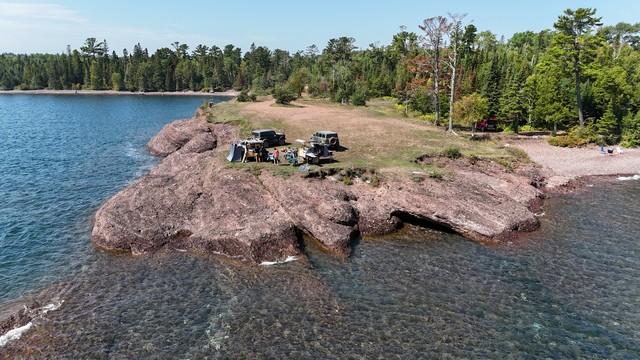
Once we got to the end, the "best" site at the tip of the peninsula was wide open. I say "best" because the view and photo ops are great, but there is literally no protection from the elements. If it's windy, or you're in something without hard sides, I dunno if I'd camp out there, but it worked out perfectly for our trip. There are plenty of other more protected campsites with easy access to the lake though.
After setting up camp, we made lunch, took a dip/bath in the super cold lake superior and just enjoyed this incredible camp site.
Day 5, Tuesday
 We woke up to a beautiful sunrise over Lake Superior, played around a bit, and then decided to do some bronco exploring on the nearby trails. The trails had plenty to offer, but we accidentally wound up on one side-by-side trail, which was regrettable. We luckily had some loppers and fresh PPF film on our Broncos, but man, it was tight and annoying. The rest of the trails were great though. Some technical rocks, puddles, logs, tight sections, fast sections, and Club Superior.
Club Superior is an abandoned cabin that's available for use as long as you can respect it. It's pretty rickety, but has a working wood stove and some protection from the elements if you need it. It's fun to check out at the very least.
So, after a bit of wheeling, Kari and I decided to pack up and hit trail to make our way partially home since we were now 12+ hours away and had work on Thursday.
I'd hoped to see some bears and plenty of other wildlife along the trail, but we saw almost nothing. However, halfway back through Wisconsin a couple black bears ran across the road right in front of us. Super cool.
Final thoughts
Overall, the trip and trail were super fun. There are long stretches of gravel and even pavement, but it's very scenic, scratched the off-road itch, and was a great test of our off-road trailers. The broncos were unfazed by anything on the trail, but a higher-clearance vehicle is definitely necessary for some of the 2-track and deep forest trails.
Everything you take along with you will be covered in dust and red mud, but not like soupy mud. Most of these areas had a nice rock base.
Trying to bomb this trail in 7 hours with a truck / SUV would also be super fun, but I think taking our time was just as nice. I honestly wish we would've taken even more time and had some layovers at a couple of the sites.
Anyway. I definitely recommend the 7-hour plane crash trail as a quick overland road trip. It’s not incredibly technical, but definitely fun.
Here are some more of my photos.
I'm working on an updated, more detailed GPX as well. If you'd like it, let me know!